There are places in Oregon that remind you how much real wilderness is still out there if you are willing to put in the miles to reach it. Steens Mountain is one of those places. Rising to 9,733 feet from the floor of the Alvord Desert in southeastern Harney County, the Steens is a fault-block mountain unlike anything else in the Pacific Northwest. The east face drops nearly a vertical mile to the Alvord playa in under five miles. The west slope rolls off in long, glaciated gorges filled with aspen, willow, and cold spring water. In late May and early June, when most of Oregon's mountains are still locked under snow, the lower Steens is coming alive and largely empty.
Why Backpack the Steens?
Unlike most Oregon wilderness areas, the Steens sees almost no backpacking traffic despite holding spectacular terrain. Most visitors day-drive the Steens Mountain Loop Road, see the rim views, and leave. The gorges on the west slope — Blitzen, Kiger, Little Blitzen, Wildhorse, and Fish Lake drainages — are nearly always empty on foot. You will see wild horses, pronghorn, mule deer, bighorn sheep, and a density of raptors that will make your bird-watching companions lose their minds, all without another soul in sight.
Season and Timing
The Steens is a late-season destination. The Loop Road typically opens in late May or early June after snowmelt clears it, but the lower gorges and west-slope trails are often accessible from late April onward via foot access from the south end of the mountain.
Late May to early July is the sweet spot. The gorges are green, spring flowers are exploding on the slopes, water sources are reliable, and temperatures are manageable. Mid-summer brings heat, aggressive mosquitoes at lower elevations, and dry conditions. Fall (September-October) is spectacular for color and wildlife activity but can turn to snow with no warning at elevation.
A 3-Day Route: Blitzen Gorge and the Big Indian Loop
This route starts at the Page Springs Campground (Bureau of Land Management), about 3 miles east of the town of Frenchglen on the Steens Mountain Loop Road.
Day 1: Page Springs to Blitzen Crossing (8 miles, 1,200 ft gain)
From Page Springs, pick up the South Steens Trail heading north along the Donner und Blitzen Wild and Scenic River. The Blitzen is crystal clear and cold, fed by springs high on the mountain. You will cross it multiple times on this route, so bring poles for the knee-deep sections in May. Follow the river upstream through cottonwood and willow bottoms into rising terrain. Camp at the upper Blitzen meadow area around mile 8, where a large flat bench with established fire rings and reliable water makes an ideal base. Elevation around 5,400 feet.
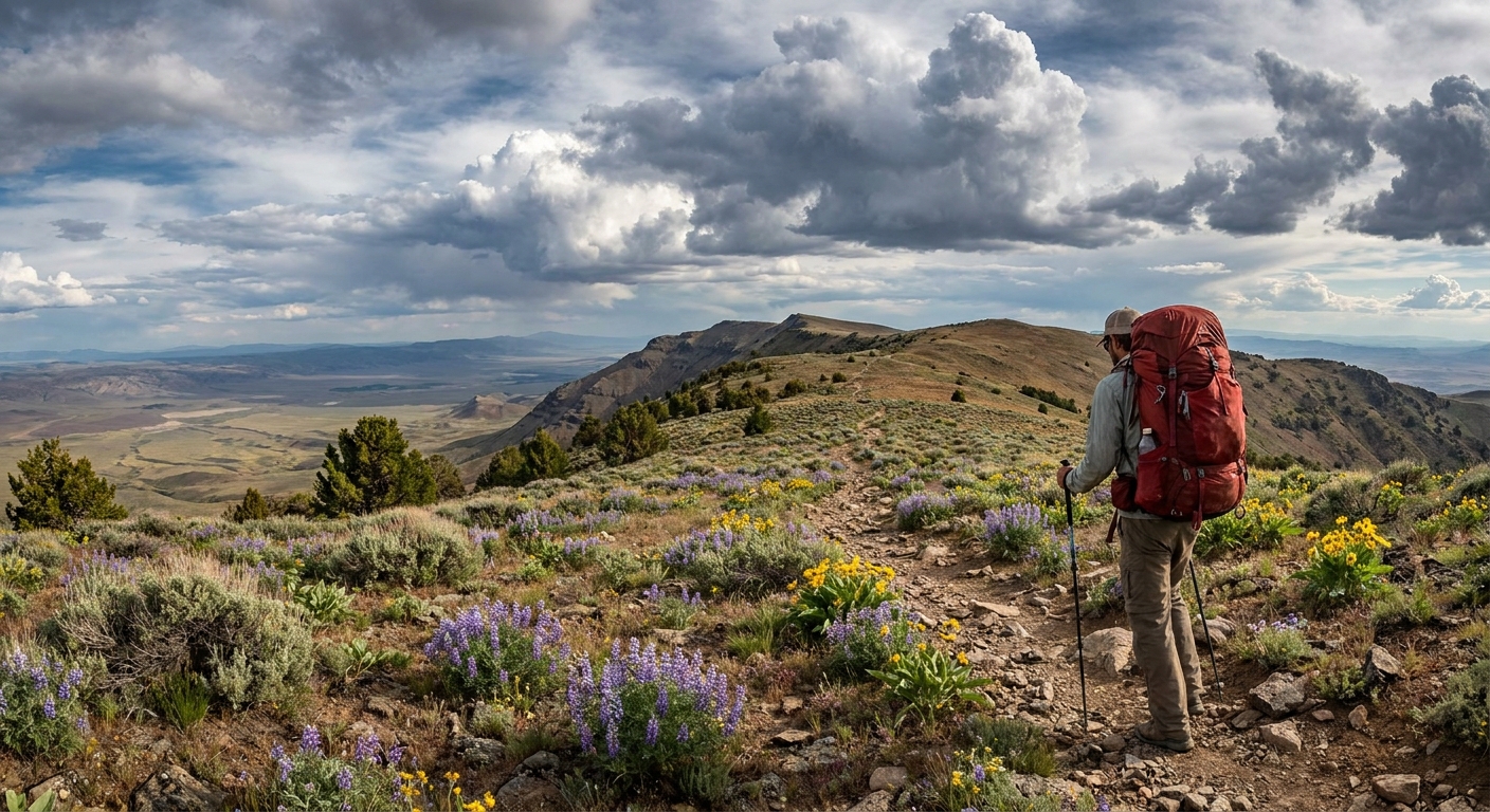
Day 2: Blitzen Rim Loop to Wildhorse Lake (10 miles, 2,400 ft gain)
This is the big day. Climb the east slope of the gorge on a faint game trail to gain the rim of the Blitzen Gorge at around 8,200 feet. The view from the rim looking back down the gorge and west across the desert is worth the climb alone. Continue north along the rim to Wildhorse Lake, a glacially carved cirque lake at 8,400 feet that holds rainbow trout and sits directly below the summit ridge. The lake is typically ice-free by late May in mild years, earlier than the upper rim. Camp here for a true high-country experience. Bring a trowel and pack out your waste, as the no-trace requirements around the lake are strictly enforced.
Day 3: Wildhorse Lake to Page Springs via Kiger Gorge Trail (9 miles, 2,600 ft descent)
Descend via the Kiger Creek drainage back to the valley floor. The upper Kiger gorge is one of the most scenic stretches of trail on the mountain, dropping through basalt cliffs draped with seeps and wildflowers into the broad lower valley. Wild horses frequent this area and you have a high probability of close encounters. Rejoin the Loop Road near the Kiger HMA overlook and walk the final 2 miles back to Page Springs.
Gear Considerations
- Water: Plentiful from springs and the Blitzen system. Treat everything regardless of how clear it looks. A gravity filter or squeeze filter handles the volume you will be moving.
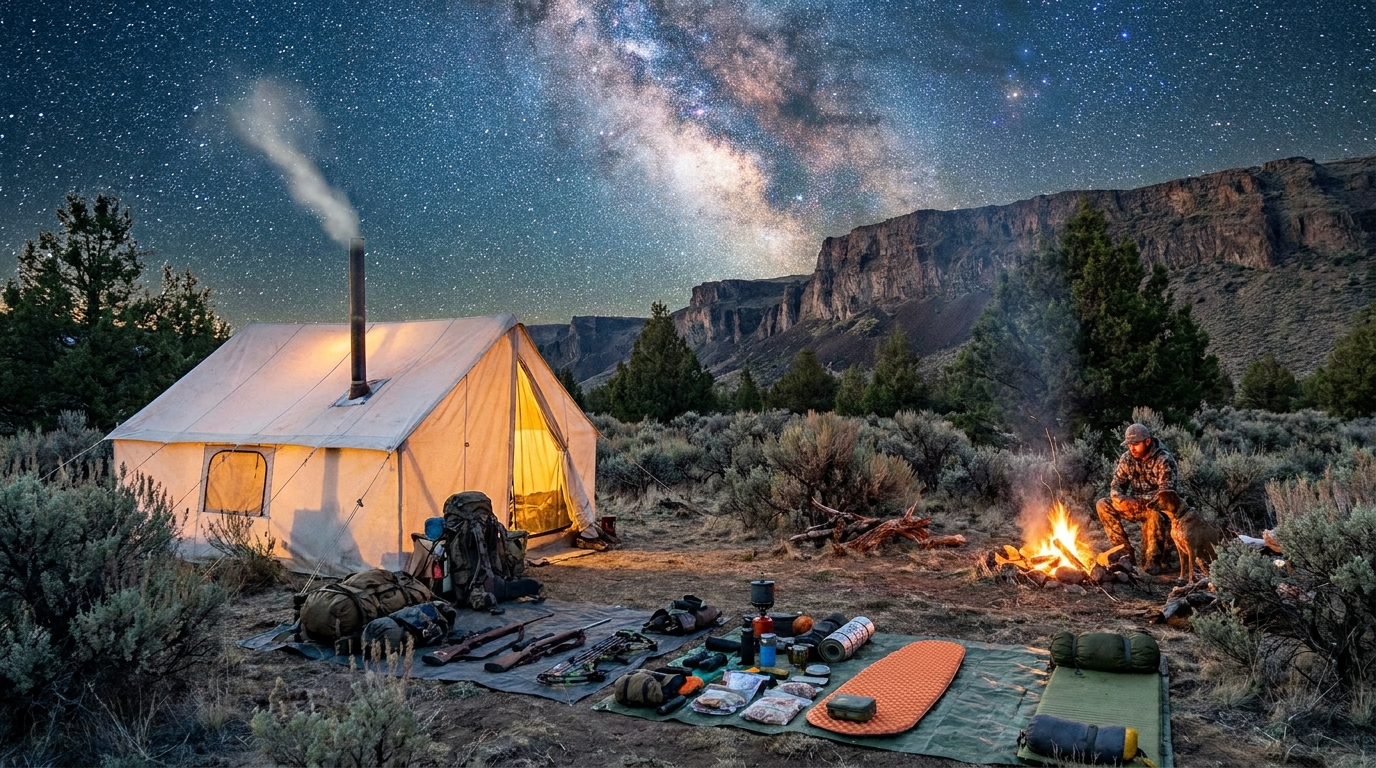
- Shelter: Four-season or solid three-season tent. May storms on the Steens come fast and hard. Snow at elevation is possible through June.
- Layers: Midday temps can reach 70 degrees. Nights at 8,000 feet in May regularly drop to 28-35 degrees. Down puffy, wind shell, and a 20-degree bag are not overkill.
- Footwear: Waterproof trail runners or lightweight boots. You will be wet from creek crossings regardless.
- Navigation: Cell service is nonexistent. Download the Avenza PDF topo for the Steens or carry a printed USGS quad. A GPS unit with topo maps is strongly recommended on the rim sections where trails fade.
Permits and Regulations
No overnight permit is required for backpacking on the Steens as of current BLM rules, but this can change. Check with the Burns BLM District Office before your trip. Page Springs Campground charges a small fee for vehicle parking. Campfires are prohibited above 7,000 feet from July 1 through October 31, and banned entirely during high fire danger periods. A stove is mandatory gear.
Getting There
Frenchglen is 60 miles south of Burns on Oregon Highway 205. The Steens Mountain Loop Road begins just east of Frenchglen. From Portland, plan on 5.5 to 6 hours of driving. From Bend, about 3.5 hours. There is no fuel available in Frenchglen, so fill up in Burns or Bend. The Frenchglen Hotel, a historic Oregon State Parks property, offers simple meals and lodging if you want to stage a night before or after your trip.
Final Word
The Steens Mountain wilderness is one of the genuine gems of the American West. Three days in the gorges will recalibrate your perspective in ways that are hard to put into words. Bring a camera, a fishing rod for the Blitzen trout, and extra food for a summit attempt if the weather cooperates. Leave your phone in the truck.